
Madera County
- Madera County – List of Stone Quarries, Etc.
- Madera County Granite Quarries (historical up to 1906) – Excerpts from The Structural and Industrial Materials of California, Bulletin No. 38, California, State Mining Bureau, San Francisco, California, 1906.
- Madera County Granite Resources circa 1913 – Included in chapter on “California” (pdf), by G. F. Loughlin, in the Mineral Resources of the United States Calendar Year 1913, Part II. Nonmetals, United States Geological Survey, 1914.
- Madera County Mines and Mineral Resources (circa 1913-1914) – Excerpts from Report XIV of the State Mineralogist - Mines and Mineral Resources of Portions of California, Chapters of State Mineralogist's Report - Biennial Period 1913-1914, Part IV. “The Counties of Fresno, Kern, Kings, Madera, Mariposa, Merced, San Joaquin, Stanislaus,” 1916.
- Madera County Mineral Industry (circa 1919) – Excerpt from California Mineral Production for 1919, Bulletin No. 88, by Walter W. Bradley, California State Mining Bureau, 1920.
- Madera County Limestone Industry and Deposits (through 1947) – Excerpt from “Limestone in California,” by Clarence A. Logan, California Journal of Mines and Geology, Vol. 43, No. 3, July 1947, California Division of Mines, San Francisco, California.
- McGilvary Granite Quarry (Inactive), Photographic Tour, Knowles, California (photographs taken Sept. 2010)
- Raymond/Knowles Granite Quarries, Madera County, California – Towns of Raymond & Knowles and the Raymond Granite Quarry & the Knowles Granite Quarry – Photographic Tour (To read the account of our trip to the Knowles and Raymond Granite Quarries in July 1998 go to our Visit to the Raymond Granite Quarries page.)
- Raymond Museum - Photograhic Tour, Raymond, California (photographs taken Sept. 2010)
- Madera County Granite Quarries (historical up to 1906) (Excerpt
from The Structural and Industrial Materials of California, Bulletin
No. 38, California, State Mining Bureau, San Francisco, California,
1906.)
"The granite quarries near Raymond are at present large producers. There are two quarries in operation (September, 1904), employing about 300 men, and at times it is said as high as from 400 to 500 men. The quarries are located about 2 miles southeast of the village of Raymond, on a spur of the Raymond branch of the Southern Pacific Railroad. The two quarries are about half a mile apart, on the east side of the little valley in which they occur.
"There is an extensive granite area covering many square miles in the vicinity of Raymond. Near the town is a hornblende biotite granite, but at the quarries there is almost no hornblende except an occasional crystal. In many places the granite is disintegrated to a depth of many feet, while over limited areas it outcrops firm and solid on the surface. It is on such areas that the quarries should be located. The weathering of the granite is mainly by slow disintegration over the surface and along the joint planes. There are very few of the round residual boulders so conspicuous in many places. Most of the surface boulders are angular.
"Among the many structures built of Raymond granite may be mentioned the new postoffice in San Francisco, which was furnished $425,000 worth, with only one small stone needing replacement; the Fairmount Hotel was furnished about 20,000 cubic feet; the Dewey Monument, in Union Square; the Mercantile Trust Company, of San Francisco, on California street, and numerous others."
- Madera County Mines and Mineral Resources (circa 1913-1914) – Excerpts from Report XIV of the State Mineralogist - Mines and Mineral
Resources of Portions of California, Chapters of State Mineralogist's
Report - Biennial Period 1913-1914, Part IV. "The Counties of
Fresno, Kern, Kings, Madera, Mariposa, Merced, San Joaquin, Stanislaus," by R. P. McLaughlin and Walter W. Bradley, Field Assistants (field work
in July, 1913, and July, 1914), San Francisco, California, July, 1915,
California State Mining Bureau, San Francisco, California, 1916, pp. 173-370.
"Madera County, which was created March 11, 1893, has an area of 2112 square miles. It was formed from Fresno County which adjoins it on the south and west, the San Joaquin River being the boundary line between the two. On the north are Merced and Mariposa counties, with Mono on the east.
"Madera County is longest – approximately 100 miles – in a northeast-southwesterly direction. The western half is in the San Joaquin Valley proper, while the eastern boundary line runs along the summit of the divide of the Sierra Nevada Mountains and possesses a number of peaks exceeding 12,000 feet in altitude. Among these may be mentioned: Mt. Lyell, 13,090, Rodgers Peak, 13,056; Ritter Mountain, 13,156; McClure Mountain, 12,500 feet; Banner Peak, 12,957 feet; and the Minarets, 12,000 to 12,278 feet. The high Sierran section abounds in glacial lakes and meadows. The Devil's Post Pile, a knob of hexagonal, basaltic columns, which has been designated as a 'National Monument' is in this part of Madera County near Mammoth Pass and the head of the Middle Fork of the San Joaquin River.
Geology (of Madera County)
"A detailed geological survey was not made, but a general description can be given, as the relations of the formations are comparatively simple. There are several parallel belts running northwesterly across the county.
The western part of the county (the San Joaquin Valley) is nearly level and consists of sedimentary and alluvial beds lying nearly horizontal. These horizontal beds rest on steeply dipping schist which is exposed in the westerly foothills forming the eastern margin of the San Joaquin Valley.
"The schist belt is 4 or 5 miles wide, its western boundary being the eastern edge of the flat floor of the San Joaquin Valley. The eastern boundary of the schist is a contact with granite or granodiorite which line runs as follows: From the western base of Green Mountain crossing the Southern Pacific Railroad about 1 mile east of Jesbel to a point near Sesame. This zone of schist contains the copper deposits of the county. It has been looked upon favorably by some people desirous of prospecting for oil, but of course no such occurrence is probable or even possible.
"The granite occupies a zone from 5 to 10 miles wide, its eastern boundary being schist or slate. This line of contact runs southwest from Grub Gulch to Coarse Gold and the vicinity of Hildreth. The granite or granodiorite is usually coarse-grained and decomposed for a depth of about 20 or 30 feet. Exceptional spots exist where the rock is fine-grained and not decomposed to great depth. It is these exceptional spots which furnish the valuable deposits of building stone. Dikes are in evidence in various parts of the area standing up as ridges 40 to 50 feet wide. The dikes observed were of finer texture than the surrounding rock and possibly composed of different minerals, as muscovite was noted in some of them.
"Schist and slate exist as a belt from 3 to 5 miles wide along Potter Ridge. Its eastern boundary is a contact with a large body of granite. The contact runs immediately west of Wassamma ('Poison Switch') and near Lone Cedar Ranch. Granite dikes, from a few feet to ¼ mile wide, cut the slate and schist in many places. This is more fully illustrated with a drawing by W. H. Storms, Report of the State Mineralogist, XII, 1894, p. 166. This belt of schist and slate carries most of the gold bearing veins of the county. Toward the east, into the high Sierras, most of the rock is granite, with some metamorphic areas near Mt. Raymond and around The Minarets. Within the larger granite area, occupying the eastern portion of the county, are found smaller areas of metamorphic rock, largely quartzite.
"Mt. Raymond, White Chief Mountain and Iron Mountain, T. 5 S., R. 22 and 23 E., immediately east of the Mariposa Big Tree grove, are composed largely of metamorphic rocks. The most of it is quartzite which in some places shows the original bedding very much contorted. In most places, however, the rock is massive and cut by numerous fractures or cleavage planes. Granite and possibly other igneous rocks are observed occasionally as though intruded in large masses. South of the Big Trees, along the road from Summerdale ('Fish Camp') to Mt. Raymond, basic igneous rock occurs, probably as surface flows similar to those observed farther east.
"Considerable prospecting was done in the region some twenty or thirty years ago, apparently without favorable results. Recently (circa 1914) considerable work has been done in prospecting for iron and copper. Specimens of the following minerals were collected in the district: sphalerite, pyrrhotite, magnetite, chalcopyrite, pyrite, bornite and siderite.
Geologic Notes – Sierra Nevada Mountains, Southwest of Mono Lake (in Madera County)
"The following geologic observations were made during a hasty trip and are presented as of possible value to future work in the neighborhood:
"At the head of Bloody Canyon midway between Sardine Lake and Walker Lake is a contact of granodiorite and metamorphic rock, the latter lying to the west. The red color of the canyon sides seem due to iron oxide from the weathered metamorphic rocks. Dikes of considerable size cut the granodiorite.
"The metamorphic rock from Mono Pass to Parker Peak are mostly of a slaty nature, almost black. They dip steeply and are probably a portion of a fold formed at the time of the granite intrusion. All of the dips observed by the writer were to the west, but, according to the old State Geological Survey, farther north and west the series dips toward the east, indicating a synclinal fold. Bedding is distinct and singularly regular in strike, especially near Parker Peak, where it is N. 25 W. About ½ mile east of Mono Pass schist and conglomerate accompany the slate. Very little quartz float is observed in the debris but at Mono Pass there are several old prospect holes all apparently idle for many years. Running N. 25 W. for about 2 miles from the summit of Parker Peak is a particularly noticeable light colored bed or dike following the bedding. About 1 mile west of Parker Lane, on the north side of the canyon, is a very prominent outcrop exposed for several thousand feet and suggesting by its appearance a quartz ledge. The western edge of this metamorphic mass is clearly exposed in contact with granitic rocks and runs along the following southerly line from a point ½ mile west of Tioga Pass to a point ¼ mile east of Mammoth Peak, thence along the eastern base of Kuna Crest near the west shore of Helen Lake and about ¼ mile west of Kuna Peak. The entire region is smoothed off by glaciation. Some prospecting work was done in past years at the foot of the permanent snow bank of the slope of Kiop and Parker peaks, evidently without success.
"South of Parker Peak the metamorphic series continues its western margin, being near Kiop Crest and extending to the west shore of Gem Lake and its eastern margin being somewhere to the east of the ridge from Mt. Wood to Agnew Lake. At the south shore of Alger Lake the dip is about 45 to the southwest and about 80 to the southwest near Gem Lake. One fourth mile north of Alger Lake is an exposure of quartz, about 10 feet wide and 300 feet long, upon which some prospecting has been done, otherwise but little quartz was seen.
"From Gem Lake to Agnew Meadows the metamorphic series continues clearly exposed with steep western dip and uniform northwestern strike. In this region there are numerous quartz veins conforming to the bedding. The North Fork Mining district was formed here in 1878, and some prospecting work was continued until 1892 when E. B. Preston described the district (Report State Mineralogist 1892, p. 218) as showing some ten veins on the east side of the Middle Fork of San Joaquin River, within a distance of about 3000 feet across the formation, having an average width of 45 feet each, the largest being 75 feet wide and the smallest 15 feet wide. 'An average assay made in the State Mining Bureau from a sample of mixed ores from the different veins gave a higher result (than $30) in - silver and (over 17 per cent) lead. Some samples from the west side veins showed a yield of 30 per cent copper and 27 ounces silver.' The report also states that there are some nine veins on the west side of the river averaging 30 to 40 feet in width, carrying a large percentage of copper. The average sample above mentioned was not, it is learned, taken across the entire vein widths but only in its mineralized streaks. The district is now entirely idle.
"The most easterly exposure of the metamorphic series in this neighborhood is at the edge of a more recent flow of basic lava, which apparently forms the summit of the ridge bounding Mono and Madera counties. This line of contact runs from the south end of Gem Lake near the trail for a distance of about 3 miles; thence gradually toward the east and over the summit about 2 miles south of Deadman Pass. The western or metamorphic side of the valley is of the usual smooth glacial shape while the eastern or lava side is terraced, which brings up the question as to age of the lava as compared with the glacier.
"The western margin of the metamorphic series crosses the river about ½ mile north of Soda Spring and courses about S. 25 E., thence the prevailing country rock in a southwesterly direction is granitic. Occasional patches of basaltic lava lying on the granite, are encountered on the trail to Little Jackass Meadow, as follows: One mile south of Soda Spring, at the Devil's Post Pile; on the summit between Snow Canyon and Stairway Creek; and an outcrop extends for several miles along the eastern bank of the North Fork of San Joaquin River near Sheep Crossing.
"Between Devil's Post Pile and Stairway Creek there is a thin mantle (possibly 2 feet) of pumice on the granite. Fragments larger than ½ inch are seldom seen. East and south of Devil's Post Pile for a considerable distance granite appears to be the prevailing rock although Mammoth Mountain is probably metamorphic. About 2 miles southwest from Mammoth Pass are two small craters, readily distinguished in the distance by their shape and color.
"The lava at Devil's Post Pile is described by Preston as being glaciated, but also showing pumice cones of very recent date. The lava near Sheep Crossing has some glacial drift resting upon it. It lies in almost horizontal terraces and the topography several miles southwest suggests an extensive flow since cut by canyons.
"In the vicinity of Little Jackass Meadow there is an extensive covering of glacial drift containing mostly granitic, some metamorphic and very rarely basaltic boulders.
"One mile west of Little Jackass Meadows is an exposure of metamorphic rock (fine quartzite with a little mica) striking N. 15 W. Surrounding granite is glaciated.
"From Little Jackass Meadows to Yosemite Valley, by way of Fernandez and Merced passes, only granite is seen.
Resources (in Madera County)
"As will be noted from the Table of Mineral Production (p. 111) the following have yielded commercial quantities to the end of 1913 in the order named: gold, granite, copper, silver, brick, stone industry (outside of granite for building stone) and lead. In addition to these, occurrences are known of asbestos, iron, mineral water, turquoise and zinc, though as yet no commercial production of them has been made. The iron deposits...are among the most important in the State…."
Table of Mineral Production (Madera County from 1893 – 1913) 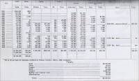
"As has already been mentioned, previous to 1893, Madera County was a part of Fresno. Of the $1,555,888 gold and the $25,657 silver credited to Fresno County in the United States Mint Reports for the years 1880 to 1892 inclusive, between 80 and 90 per cent came from that portion of its territory in the schist belt between Grub Gulch and Hildreth, for which reason, $1,350,000 and $25,000, respectively, have been added to the outputs of those two metals, bringing the total value of mineral production for Madera County properties to $5,500,677 to the end of 1913. At the present time (circa 1914), granite is the most important mineral product of the county in point of value, followed by copper and gold in second and third places, respectively.
"A recent development, which will prove of importance to the mineral industry in the future in this section of the State, is the advent of hydroelectric power. The San Joaquin Light and Power corporation of Fresno has a reservoir and a 25,000 horsepower plant at Crane Valley on the North Fork of the San Joaquin River. Its power lines are now serving not only a large part of Madera County, but also a considerable area in Fresno, Tulare and Kern counties to the south, and Merced, Mariposa, and Stanislaus to the north.
"The canal systems of Madera County, while they serve mainly for irrigation purposes, are yet worthy of mention here. The Madera Canal and Irrigation Company has more than 100 miles of ditches, distributing water principally from the Fresno River, and also from the San Joaquin river. In addition to the canals, water for irrigation is also obtained from artesian wells and by pumping. The Madera Sugar Pine Company has a 65-mile 'V' flume…by which the sawed lumber is transported from its mill at Sugar Pine to the finishing mill and storage yards at Madera. In a busy season 350,000 feet b.m. are thus brought down per day, from eleven to twelve hours being required for the lumber to travel the 65 miles. The cost is but a fraction of what it would be by teams, as there is no railroad into that section.
"The deposit is a mass of iron composed of magnetite in which no other material was observed. Its strike is NE.-SW., and its elevation about 11,000 feet above sea level. On account of the slide rock no accurate determination of the surface extent of the deposit could be made. It was estimated to be 2000 feet or more in length, 400 feet in average width, and by erosion on the northeast end it was shown to be 250 feet in depth. On the basis of these estimates there should be thirty million tons of iron ore available. Development may show a greater amount.
"The general aspect of the iron mass and the enclosing rocks point to its origin in the differentiation and segregation of materials within the original igneous magma and their consolidation in the form now exposed by erosion. An analysis of a sample taken from the face of a tunnel gave: Fe, 64.14%; Al2O3, 1.52%; CaO MgO, 0.53%; SiO2, 8.60%; P, 0.72%; Cu, none; S, 0.060%.
"The deposit is within the Sierra National Forest Reserve. It was reported that the deposit is claimed by parties who have made mineral locations. There being no persons in the region at time of examination the names of the present locators could not be ascertained. Approximately 100 feet of underground development work was found within or in close proximity to the iron deposit."
Stone Industry (in Madera County)
"The well known 'Raymond' granite quarries near Raymond, in Madera County, not only are and have been for a number of years the most important mineral industry of the county, but they are also an important factor in the state's production. As has already been noted…, these deposits of workable building stone are located in the western edge of the Sierra foothills. There are two quarries about 1 mile apart, on the east side of a small valley, about 2 miles east of Raymond, which is the terminus of the Berenda-Raymond branch of the Southern Pacific Railroad. Both quarries are served by spur tracks from this branch line. It is now recognized that this stone is not excelled by any other building granite found either in this state or elsewhere. It is noted for its beautiful white color, the fineness and uniformity of its texture, its weathering qualities, and its freeness in working. As to this last named feature, it lends itself readily to all classes of fine structural carving."
- Madera County Mineral Industry (circa 1919) – Excerpt from
California Mineral Production for 1919, Bulletin No. 88, by Walter
W. Bradley, California State Mining Bureau, 1920.
Area: 2,112 square miles
Population: 12,203 (1920 census)
Location: East-central portion of state"Madera County produced five mineral substances during the year 1919, having a total value of $110,683, as compared with the 1918 output, worth $114,327. The decrease is due to a dropping off in the output of copper, though granite increased. This county contains deposits of copper, gold, iron, lead, molybdenum, pumice, silver, and building stone.
"In forty-second place, commercial production for 1919 was as follows:
(Headings for the information below are: Substance, Amount, and Value.)
Copper, 175,405 lbs., $32,625
Gold, ---, $8,000 (estimated)
Granite, ---, $64,358
Silver, ---, $,200 (estimated)
Stone, miscellaneous, ---, $1,500
(Total value) $110,683Madera County, 1916 Map, from California Mineral Production for 1919 (with County Maps), Bulletin No. 88, by Walter W. Bradley, California State Mining Bureau, San Francisco: California State Printing Office, 1920, pp. 190. 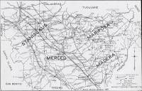
- Madera County Limestone Industry and Deposits (circa 1947) –
Excerpt from “Limestone in California,” by Clarence A. Logan, California Journal of Mines and Geology, Vol. 43, No. 3, July 1947,
California Division of Mines, San Francisco, California, pp. 175-357. Used
with permission, California Department of Conservation, California Geological
Survey.)
"There has been no recorded production of limestone from Madera County, but there is ample evidence of the occurrence of more or less siliceous limestone and marble in the number of prospects of scheelite in tactite which were found during the last war. Most of these are so far from railroads that there seems little probability they will prove of interest as sources of limestone. A list of these scheelite prospects with their locations is given by Jenkins (42, pp. 333-337).* Most of them are in the three tiers of townships in R. 22, 23, 24 E., M.D. which are in the high Sierra Nevada region and in part astride the summit. The western-most deposits (those nearest the railroad) are described below.**
(* Olaf P. Jenkins, Tabulation of Tungsten Deposits of California, to accompany Economic Mineral Map No. 4, California Division of Mines Report 38, pp. 303-364, 1942.)
(** These entries will be listed below according to the location of the quarry or deposit.)


Commercial use of material within this site is strictly prohibited. It is not to be captured, reworked, and placed inside another web site ©. All rights reserved. Peggy B. and George (Pat) Perazzo.